Monday, January 18, 2021

The Mosier Twin Tunnels Cliff Walk


Pictured above is the west entrance of the Moiser Twin 
Tunnels, circa 1920. And there's the cliff walk and the stairs, looking the same as it does today, 100 years later. You can see rock debris on the roadway and this was a problem on a daily basis with the tunnels and the west segment of the HCRH was is approached the tunnels. Falling rock was a hazard for pedestrians between the tunnels and for those who ventured out on the cliff walk. 


The Mosier Twin Tunnels in 1920. Tunnels were intentionally left unfinished on inside to give a cave like atmosphere. It was found early on that this allowed pieces of rock on the tunnel ceiling to break loose and fall on cars as they traveled thru the tunnel. The void between the two tunnels created a different hazard as rocks the size of baseballs and footballs could tumble down the hill from above onto highway travelers or sight seers who dared to venture out on the cliff walk terrace to catch a unique glimpse at the gorge. Enter at your own risk the sign said.


Mosier Twin Tunnels

1917-1921 MTT constructed

1920 Signs placed at tunnel entrances saying watch for falling rock and enter at your own risk

1920 MTT lined with timbers to prevent rocks from falling on cars

1931 MTT called unsafe with increasing traffic

1932 Traffic signals for one way traffic installed

1953 MTT deemed unsafe by State Highway Commission

1953 MTT and adjacent highway closed

1954 Rockfall at MTT collapses ceilings and blocks entrances

1954 MTT permanently closed and filled with debris

1954 HCRH/MTT segment located in Wasco County returned to adjacent private property owners. HCRH located in Hood River County maintained by HR

1987 Gorge residents want tunnels re-opened

1995 Work begins clearing backfill and rock debris from tunnels

1997 Rock catch structure installed between tunnels

1997 Cliff Walk between tunnels rebuilt including steel fence and bars restricting access

1999 Rock catch structure completed along west approach to tunnels


The

Coronated

Crowned

Bride

Dalton

Multiple

Ainswo

Dod

Warren

Bonney

Sunday, August 31, 2014

Dodson, Oregon

Dodson is a small community located between Multnomah Falls and Bonneville Dam on the old Historic Columbia River Highway.  There isn't much left of it anymore.  At one time, Dodson was a railroad stop on the Union Pacific railway.  The town of Dodson was named after Ira Dodson, an early settler and land claimant in the area.  Dodson was once the site of the McGowan salmon cannery and fish wheel (1900). Dodson has a boat launch on the Columbia River.


Image may contain: tree, house and outdoor, possible text that says 'DODSON CAFE AND SERVICE DODSON'


Image may contain: tree, plant, sky, house, outdoor and nature


 Dodson Station

In it's day, Dodson had a motel, service station, a combination store/cafe, a school and several large dairy farms.  The Dodson motel consisted of 10 units. To the east of the motel was a cafe and a grocery store.  The gas station and the cafe were adjacent to each other and were often owned and/or operated by a "Mom and Pop".  There was a school in Dodson (Bonneville Grade School), but it closed in 1996 because of a mud slide and declining enrollment.

The main significance of this small town is historical.  It is a vanishing stop located on the Historic Columbia River Highway and like many of the other stops, it is fading into oblivion.


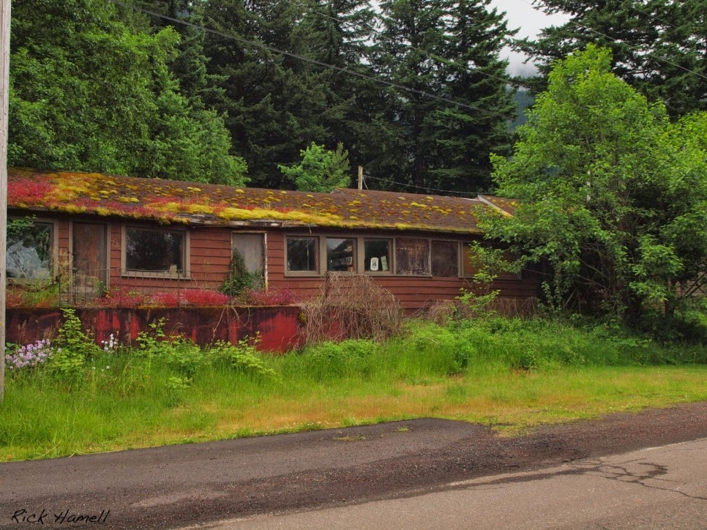
Pictured below is the Bonneville Motel, located in Dodson.

Image may contain: text and outdoor


The Bonneville Motel was owned and operated by Oliver H Jones for about 2 decades thru the 40's and 50's. The motel sign still stands near old Hwy 30 in Dodson.


Pictured below is the Dodson store with attached living quarters.


Picture below taken Sept 1, 2014

I had the pleasure of stopping into the store once when I was a kid.  I remember walking up the steps and going in there to buy a candy bar. The store was not busy and had just some basic things, food, soda pop, beer, chips and probably cigarettes.  The inside was dated and kinda run down.  Looking at the picture above, you would enter the store thru the door on that was located on the front left. 


Stories from Highway Travelers

Story from Jeff:  "I was fishing with my Step Dad for sturgeon over on the Columbia River at Bonneville.  It was 1975.  We didn't catch anything and my Step Dad drove us over to the Dodson store to buy some things.  He was low on money and wanted some beer (Heidelberg) and cigarettes (Kool's).  He had obviously been out to this place before because he put the beer and cigarettes on his tab and left his fishing pole in the store window for collateral!  The store owner didn't have a problem letting him do this.  I think he had done it a few times before.  Never forget that one."

A while back (2011), someone broke out the front window of the store.  This picture was taken before they boarded it up with plywood.  Interesting look inside.  Notice the cash register in the corner.  This was probably the store and the motel business office.


It looks like one of the last things they did was try to sell everything.  There is a sign that says: "your choice $15".  Also there are price tags on some of the other things in there.


Pictured below is the fish wheel that was once located in Dodson (1900)

 
Dodson's service station now sits abandoned.


This station was a Flying A service station in the 60's
Picture above taken Sept 1, 2014


The motel sign still stands today.

The completion of the new "water grade" freeway in the early 1950's spelled the end for Dodson Station.  The new freeway not only bypassed their business but it created fast and easy access to Portland.  In addition, it led to new business opportunities at the freeway interchanges and off ramps.  This was a death sentence for the Dodson gas station and motel. They kept it open into the 1970's but it was a losing battle once the new freeway took away most of their customers.


Bonneville Grade School

School was six miles west in the community of Dodson. Bonneville Grade School -- eight grades in four classrooms -- never had an enrollment of more than 70 or so students, most of whom lived at the dam.
    High school students went to either Cascade Locks or Stevenson.  The school closed in 1996, its enrollment down to 11 students, its building heavily damaged by landslides caused by severe winter weather. When the 1996 mudslides took place, the school was compromised. The Bonneville School was later sold and currently is used as a storage facility.


Bucher Dairy Farm


Picture of barn in Oct 2007

 The Hollywood Dairy was owned by Joe Bucher and his family.  Purchased in 1929, the 750 acre dairy provided milk for over 40 years to the Dodson and surrounding communities.  At it's peak, the dairy had a herd of 70-80 cows and produced 1200 quarts of milk a day.  The large barn was a landmark in the Dodson area.  Built in the early 1900's, the barn stood for about 100 years.  Sadly, the barn came down in 2010 and is gone.


 At one time, Dodson was a railroad station named "Dodson's".


Dodson Landslide


On February 8, 1996 a massive landslide gave way on the south side of the valley. Actually it began the day before with slides coming down all over the gorge. It had been raining hard for several days. The snow had melted at the top of the cliff which was unusual, adding even more water.  Around noon on February 8th, a 2,000 feet vertical cliff gave way. The earth shook as the huge wall of mud, water, rocks and trees roared down toward Carol & Hersh Royse’s farmhouse on the frontage road along Highway 84. They ran out in the front yard, crawled through the board fence and down through the field to the frontage road.
The slide engulfed the farmhouse, filling the basement and first floor with water, mud and rocks up to the kitchen counter tops and tore out the living room on the west side. It pushed their earth stove about 100 feet out in front of the house. Four to 15 feet of mud, boulders and trees completely covered their property down to the Frontage Road.

Potential Historic Sites in Dodson:

Bucher's Farm
Dodson Motel
Former Sherman's Inn Tavern
Mountain Shadow Cottages

If you have any info or a story you would like to share, please email me at: rumblefish351@aim.com

Thanks for stopping by!

Monday, September 8, 2008

Foot Bridge Over Highway at Latourelle Falls


This foot bridge over the HCRH (located just west of Latourelle Falls) connected two sides of a country estate thru which the highway right of way ran and divided into two parts. This photo was taken from a postcard (circa 1920).

Tuesday, September 2, 2008

The Hood River Bridge


The Hood River Bridge was built in 1918. It was the longest bridge (404 feet) of the 26 original bridges built for the HCRH. Demolished in August of 1982, the destruction of this bridge caused a public outcry creating passage of legislation that would protect the remaining sections of the highway. Because of this, sections of the highway underwent restoration and preservation. There is a plan to eventually connect the remaining segments. Perhaps one day, a "restored" HCRH will once again run from Troutdale to The Dalles as one continuous highway.

There is limited data available on this bridge. If you have some information about this bridge, please contact me.

rumblefish351@aim.com

Sunday, August 31, 2008

The Tooth Rock Viaduct


Designer: L. W. Metzger
Engineer: Oregon Highway Department
Length: 1.5 miles
Year Built: 1915
Cost: $24,000


Tooth Rock Viaduct

Constructed in 1915, the tooth rock viaduct was a bridged roadway built into the rock hillside around the Tooth Rock Bluff. One and a half miles long, it is located between Eagle Creek and Tanner Creek. It offers magnificent views of the Columbia River and Bonneville Dam. It has been described as a hanging bridge on a rock face. This engineering feat was a compromise between a tunnel and a bridge. The cliff side was blasted to form a shelf where a viaduct could be constructed. Half of the roadway was laid on this ledge while the other half was built out on an overhanging viaduct. This unique section of roadway was part of the original CRH from 1916 thru 1937. The construction and opening of the Tooth Rock Tunnel in 1937 rerouted traffic underneath this portion of the highway. It was abandoned and sat dormant for many years. From the 1940's thru the 80's, it was neglected and began falling apart. In 1996, concerned citizens formed an organized group to oversee the restoration process of several sections of the CRH. This part of the old highway is the first phase in rebuilding the entire highway from Troutdale to The Dalles. The rebuild on this section was completed in 1996. It now serves as a bike and walking trial.


The photo below was taken from a postcard dated 1916


Below, construction crews pose with their horses after completion of the viaduct in 1915.

Work gangs of men construct the viaduct roadway with form boards, reinforced concrete and steel girders in 1915.

Friday, August 29, 2008

Mitchell Point Tunnel

Designer: John A. Elliot (University of Washington) State Highway Engineer: Henry L. Bowlby (West Point Graduate) Tunnel Length: 385 feet Cost to Build: $50,000 Year Tunnel was Built: 1915 Rock Type: Basalt The Tunnel of Many Vistas
The Mitchell Point Tunnel was bored thru a rocky cliff overhanging the Columbia River. It was 385 feet long with 5 arched windows with parapets and benches to sit on. The large projecting rock cliff was called "Little Storm Crest" by the Indians. The large mountains behind the tunnel were known as "The Great Storm Crest". The postcard below shows the west portal of the tunnel with the viaduct. When built, the two lane roadway was 24 feet wide. Broad by the road standards in 1916, ever increasing automobile and truck traffic soon obsoleted the narrow roadway and tunnel. In 1937, the construction and opening of the Tooth Rock Tunnel removed mainstream traffic from the Mitchell Point Tunnel. Below, the picture shows the tunnel under construction in 1915. Notice the ladder that workers would climb to access the tunnel during this phase of construction. The Mitchell Point Tunnel was a part of the original route of the Historic Columbia River Highway from 1916 thru 1932. Built under the supervision of John Elliot, a CRH engineer, the idea was taken from a similar tunnel located in Lucerne, Switzerland. Inspired by a photo that showed four windows and a tunnel overlooking Lake Uri and the Swiss Alps, Elliot fashioned his tunnel with five windows with views of the Columbia River, Mount Ranier and Mount St. Helens. The tunnel took over 8 months of blasting in 1918 and was a huge engineering feat. It solved the problem of traversing the roadway around or thru a prominent rock mountainside the Indians called Storm Crest. The tunnel was carved thru the natural riverbank's basalt cliff and was created with dynamite blasting and hand hewn labor. It was a spectacular accomplishment and a major highlight of the Columbia River Highway. The tunnel served as primary car and truck thoroughfare until 1932, when the Tooth Rock Tunnel was opened offering an alternative route for travelers. Eventually, the tunnel became a one-way passage with the addition of a signal which controlled the traffic flow. In 1953, the tunnel was closed and was sealed with brick and mortar. In 1966, the tunnel was dynamited to clear the way for the new section of I-84. All that remains today is the roadway floor on a shelf 95 feet above the river where the tunnel used to sit. The Mitchell Point Tunnel viewed from the Columbia River bank below.